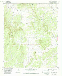
1967 Map of Adams Diggings
USGS Topo · Published 1986About this map
Adams Diggings lies at the heart of this high-altitude landscape, where the Continental Divide curves through the central hills. The 1960s terrain is characterized by a network of named draws and canyons, including Wyche Canyon and Nations Draw, which cut through the prominent Mariano Mesa. Traces of earlier habitation are evident at Indian Ruins near Techado Flat, while the mid-century ranching economy is represented by a high density of named wells and water sources like Preacher Well, Lee Wright Well, and Techado Spring. The map documents a sparsely populated region of Catron County where transportation was defined by unpaved routes such as Graveyard Road and Omega Road. Distinctive landmarks like Toms Rock and the remote Forest Hill Cem provide specific points of interest for those studying the local history of this rugged New Mexico interior.
Find a feature on this map
35 named features on this map. Tap any name to fly to it.
Don’t see what you’re looking for? This feature index may not catch every label — zoom into the map to look around manually.
Map Details
Editions of this 1967 Adams Diggings Map
2 editions found
Other maps of this area

1954 · Saint Johns
USGS Topo · 1:250,000

1957 · Saint Johns
USGS Topo · 1:250,000

1958 · Saint Johns
USGS Topo · 1:250,000

1962 · Saint Johns
USGS Topo · 1:250,000

1967 · Omega
USGS Topo · 1:24,000

1967 · Mariano Springs
USGS Topo · 1:24,000

1967 · Adams Diggings
USGS Topo · 1:24,000

1967 · Blue Hills
USGS Topo · 1:24,000
1967 · Pie Town
USGS Topo · 1:24,000

1967 · Veteado Mountain
USGS Topo · 1:24,000