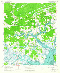
1960 Map of Adams Run
USGS Topo · Published 1964About this map
The coastal marshlands and riverine networks of Charleston County define this 1960s landscape, centered on the settlement of Adams Run. The map illustrates a complex tidewater environment where the Dawho River and Wadmalaw River meet, joined by the engineered path of the Intracoastal Waterway. This era shows a rural community structure deeply tied to local institutions, featuring an exceptionally high density of country churches such as First Zion Ch, Little Zion Ch, and Wesley Memorial Ch.
Find a feature on this map
52 named features on this map. Tap any name to fly to it.
Don’t see what you’re looking for? This feature index may not catch every label — zoom into the map to look around manually.
Map Details
Editions of this 1960 Adams Run Map
3 editions found
Other maps of this area

1918 · Cottageville
USGS Topo · 1:62,500

1919 · Edisto Island
USGS Topo · 1:62,500

1919 · Wadmelaw Island
USGS Topo · 1:62,500

1920 · Ravenels
USGS Topo · 1:62,500

1943 · Cottageville
USGS Topo · 1:62,500

1943 · Edisto Island
USGS Topo · 1:62,500

1944 · Ravenels
USGS Topo · 1:62,500

1944 · Wadmelaw Island
USGS Topo · 1:62,500

1947 · Savannah
USGS Topo · 1:250,000

1948 · Savannah
USGS Topo · 1:250,000