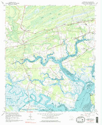
1960 Map of Adams Run
USGS Topo · Published 1983About this map
Adams Run and the surrounding lowcountry of Charleston County are defined by an intricate network of tidal waterways and islands at the dawn of the 1960s. The landscape is a mosaic of maritime forests and wetlands, where the Dawho River and Wadmalaw River flank significant landmasses like Jehossee Island and Whooping Island. This era shows the Seaboard Air Line railroad cutting through the northern settlements, linking Barrelville and Meggett to the broader regional economy. Cultural landmarks are densely clustered, with numerous community anchors such as St Pauls Sch Ch, Wesley Memorial Ch, and Baptist Hill. Along the coastal edges, the IntraCoastal Waterway winds past White Point Landing and Bears Bluff, illustrating the area's deep connection to the water. The map preserves the locations of several rural schools and cemeteries, including the Oakville Sch and Prices Cem, which serve as vital markers for local genealogical research.
Find a feature on this map
58 named features on this map. Tap any name to fly to it.
Don’t see what you’re looking for? This feature index may not catch every label — zoom into the map to look around manually.
Map Details
Editions of this 1960 Adams Run Map
3 editions found
Other maps of this area

1918 · Cottageville
USGS Topo · 1:62,500

1919 · Edisto Island
USGS Topo · 1:62,500

1919 · Wadmelaw Island
USGS Topo · 1:62,500

1920 · Ravenels
USGS Topo · 1:62,500

1943 · Cottageville
USGS Topo · 1:62,500

1943 · Edisto Island
USGS Topo · 1:62,500

1944 · Ravenels
USGS Topo · 1:62,500

1944 · Wadmelaw Island
USGS Topo · 1:62,500

1947 · Savannah
USGS Topo · 1:250,000

1948 · Savannah
USGS Topo · 1:250,000