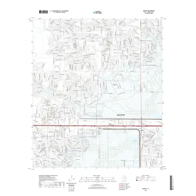
2019 Map of Addicks
USGS Topo · Published 2019About this map
Barker Reservoir and its surrounding floodplain dominate this portion of west Houston, serving as a critical piece of water management infrastructure where South Mayde Creek, Langham Creek, and Bear Creek converge into Buffalo Bayou. The map illustrates the 21st-century suburban landscape of Addicks and Barker, where dense residential subdivisions press right against the boundaries of the reservoir's open basin. Along the southern edge, the Baker Cem remains a quiet link to the area's earlier rural history, now surrounded by modern development. Significant transportation and recreation corridors define the area, including the sprawling West Houston Airport and an extensive network of paths such as the George Bush Hike and Bike Trail and the Cullen Bike and Hike Trail. The primary transit artery of I-10 and the parallel Old Katy Rd cut through the center, separating the established residential blocks from the northern reaches of the reservoir.
Find a feature on this map
33 named features on this map. Tap any name to fly to it.
Don’t see what you’re looking for? This feature index may not catch every label — zoom into the map to look around manually.
Map Details
Editions of this 2019 Addicks Map
This is the sole edition of this map. No revisions or reprints were ever made.
Other maps of this area

1915 · Alief
USGS Topo · 1:24,000

1915 · Cypress
USGS Topo · 1:24,000

1915 · Katy
USGS Topo · 1:24,000

1915 · Addicks
USGS Topo · 1:24,000

1915 · Hillendahl
USGS Topo · 1:24,000

1915 · Clodine
USGS Topo · 1:24,000

1916 · Satsuma
USGS Topo · 1:24,000

1916 · Swanson
USGS Topo · 1:24,000

1918 · Cypress
USGS Topo · 1:31,680

1918 · Addicks
USGS Topo · 1:31,680