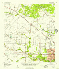
1955 Map of Addicks
USGS Topo · Published 1957About this map
Houston city limits expand into a landscape defined by flood control and petroleum production in this mid-century survey. The massive Addicks Dam and nearby Barker settlement anchor a hydraulic system designed to manage Buffalo Bayou and Mayde Creek, while the Satsuma Oil Field and Joyce Oil Field mark the region’s industrial foundations. This era captures the transition of rural Harris County into suburban enclaves, seen in the residential clusters of Spring Valley, Hedwig, and Bunker Hill.
Find a feature on this map
64 named features on this map. Tap any name to fly to it.
Don’t see what you’re looking for? This feature index may not catch every label — zoom into the map to look around manually.
Map Details
Editions of this 1955 Addicks Map
This is the sole edition of this map. No revisions or reprints were ever made.
Other maps of this area

1915 · Bellaire
USGS Topo · 1:24,000

1915 · Houston Heights
USGS Topo · 1:24,000

1915 · Alief
USGS Topo · 1:24,000

1915 · Cypress
USGS Topo · 1:24,000

1915 · Katy
USGS Topo · 1:24,000

1915 · Addicks
USGS Topo · 1:24,000

1915 · Hillendahl
USGS Topo · 1:24,000

1915 · Clodine
USGS Topo · 1:24,000

1916 · Rose Hill
USGS Topo · 1:24,000

1916 · Aldine
USGS Topo · 1:24,000