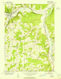
1953 Map of Addison
USGS Topo · Published 1955About this map
The village of Addison serves as a northern anchor in this mid-century portrait of southern Steuben County, where the Canisteo River and Tuscarora Creek converge. A heavy rail presence defines the local economy and transport network of the era, with the Erie RR following the river valleys and the Baltimore and Ohio RR cutting south toward the New York-Pennsylvania Boundary. In the southern half of the quadrangle, the community of Lindley sits along the Tioga River, flanked by the New York Central RR. This landscape is particularly rich for genealogists, preserving the locations of numerous district schools such as School No 7, Orr Hill Sch, and Lumber City Sch. Significant family history markers are evident in well-placed burial grounds including the Jones-Erwin Cem and Fairview Cem, while landmarks like Liberty Pole suggest old local gathering points in the township of Tuscarora.
Find a feature on this map
45 named features on this map. Tap any name to fly to it.
Don’t see what you’re looking for? This feature index may not catch every label — zoom into the map to look around manually.
Map Details
Editions of this 1953 Addison Map
2 editions found
Other maps of this area

1900 · Tioga
USGS Topo · 1:62,500

1900 · Elkland
USGS Topo · 1:62,500

1902 · Tioga
USGS Topo · 1:62,500

1914 · Corning
USGS Topo · 1:62,500

1924 · Woodhull
USGS Topo · 1:48,000

1926 · Woodhull
USGS Topo · 1:62,500

1944 · Woodhull
USGS Topo · 1:62,500

1944 · Corning
USGS Topo · 1:62,500

1950 · Elmira
USGS Topo · 1:250,000

1953 · Campbell
USGS Topo · 1:24,000