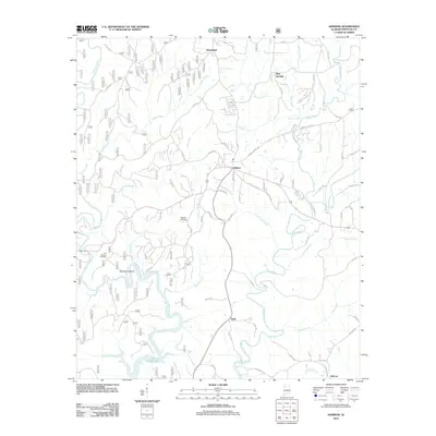
2011 Map of Addison
USGS Topo · Published 2011About this map
Addison serves as the central hub of this northern Alabama landscape, situated at the junction of several local routes such as Old Hwy 278 E and Old Cullman Rd. The terrain is defined by a dense network of drainages including Brushy Creek, Rock Creek, and Clifty Creek, which flow southward toward the northern reaches of Lewis Smith Lake. The map reveals a pattern of dispersed rural settlements and crossroads such as Eagle, Inmanfield, and New Georgia, connected by a web of county roads that navigate the intricate stream valleys. Local history is anchored by sites like Suddeth Cemetery and Old Houston Cemetery, which provide points of interest for genealogical research. To the southwest, the dramatic Horseshoe Bend on Brushy Creek illustrates the winding path of the local waterways through this corner of Winston County.
Find a feature on this map
138 named features on this map. Tap any name to fly to it.
Don’t see what you’re looking for? This feature index may not catch every label — zoom into the map to look around manually.
Map Details
Editions of this 2011 Addison Map
This is the sole edition of this map. No revisions or reprints were ever made.
Other maps of this area

1935 · Upshaw
USGS Topo · 1:24,000

1935 · Danville
USGS Topo · 1:48,000

1936 · Mc Kendry
USGS Topo · 1:24,000

1936 · Moulton
USGS Topo · 1:48,000

1938 · Danville
USGS Topo · 1:62,500

1940 · Mt Hope
USGS Topo · 1:62,500

1956 · Gadsden
USGS Topo · 1:250,000

1958 · Gadsden
USGS Topo · 1:250,000

1960 · Gadsden
USGS Topo · 1:250,000
1960 · Grayson
USGS Topo · 1:24,000