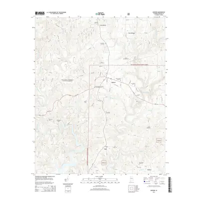
2014 Map of Addison
USGS Topo · Published 2014About this map
The town of Addison serves as the central hub of this northern Alabama landscape, situated at the junction of Us-278 and several local routes within the William B. Bankhead National Forest. This region is defined by a dense network of watercourses, including the winding Brushy Creek and Rock Creek, which feed into the northern reaches of Lewis Smith Lake. The map reveals a community deeply rooted in its local geography, with numerous family and church-affiliated burial grounds such as Alston Family Cem, Hadder Cem, and Hamner Cem dotting the countryside.
Find a feature on this map
92 named features on this map. Tap any name to fly to it.
Don’t see what you’re looking for? This feature index may not catch every label — zoom into the map to look around manually.
Map Details
Editions of this 2014 Addison Map
This is the sole edition of this map. No revisions or reprints were ever made.
Other maps of this area

1935 · Upshaw
USGS Topo · 1:24,000

1935 · Danville
USGS Topo · 1:48,000

1936 · Mc Kendry
USGS Topo · 1:24,000

1936 · Moulton
USGS Topo · 1:48,000

1938 · Danville
USGS Topo · 1:62,500

1940 · Mt Hope
USGS Topo · 1:62,500

1956 · Gadsden
USGS Topo · 1:250,000

1958 · Gadsden
USGS Topo · 1:250,000

1960 · Gadsden
USGS Topo · 1:250,000
1960 · Grayson
USGS Topo · 1:24,000