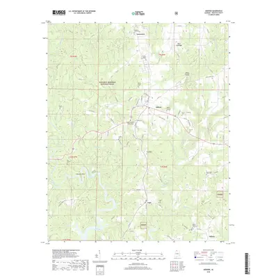
2018 Map of Addison
USGS Topo · Published 2018About this map
Addison stands as the central hub of this Winston County landscape, surrounded by a high density of rural cemeteries and country churches that speak to generations of local family history. Within the eastern boundaries of the William B. Bankhead National Forest, the topography is defined by the winding reaches of Lewis Smith Lake and a complex network of creeks, including Rock Creek and Brushy Creek. The map reveals a deeply rooted community structure, evidenced by the numerous small burying grounds like Alston Family Cem, Old Houston Cem, and Hadder Cem. Smaller settlements such as Inmanfield, Eagle, and Helicon are connected by a web of local roads, while the Addison Municipal Airport provides a modern landmark near the town center. The presence of multiple congregations, such as Fairview Missionary Baptist Church Number 2, suggests the enduring role of these centers in the social fabric of the Sipsey Wilderness area.
Find a feature on this map
106 named features on this map. Tap any name to fly to it.
Don’t see what you’re looking for? This feature index may not catch every label — zoom into the map to look around manually.
Map Details
Editions of this 2018 Addison Map
This is the sole edition of this map. No revisions or reprints were ever made.
Other maps of this area

1935 · Upshaw
USGS Topo · 1:24,000

1935 · Danville
USGS Topo · 1:48,000

1936 · Mc Kendry
USGS Topo · 1:24,000

1936 · Moulton
USGS Topo · 1:48,000

1938 · Danville
USGS Topo · 1:62,500

1940 · Mt Hope
USGS Topo · 1:62,500

1956 · Gadsden
USGS Topo · 1:250,000

1958 · Gadsden
USGS Topo · 1:250,000

1960 · Gadsden
USGS Topo · 1:250,000
1960 · Grayson
USGS Topo · 1:24,000