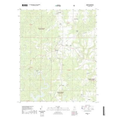
2021 Map of Addison
USGS Topo · Published 2021About this map
Lewis Smith Lake dominates the southern landscape of this Winston County region, where the winding inlets of Brushy Creek and Rock Creek meet the forested boundaries of the William B. Bankhead National Forest. The town of Addison serves as the central hub, supported by the Addison Municipal Airport and a network of county roads that connect outlying settlements like Eagle, Inmanfield, and Helicon. This 2021 survey provides a detailed look at the rural character of the area, defined by its numerous family and church burial grounds. Notable sites for local history include the Alston Family Cem, Old Houston Cem, and the Fairview Missionary Baptist Church Number 2 Cem. The terrain is marked by significant features such as Horseshoe Bend and a series of branching waterways including Clifty Cr and Boone Cr, reflecting the complex hydrology of the Alabama Cumberland Plateau.
Find a feature on this map
101 named features on this map. Tap any name to fly to it.
Don’t see what you’re looking for? This feature index may not catch every label — zoom into the map to look around manually.
Map Details
Editions of this 2021 Addison Map
This is the sole edition of this map. No revisions or reprints were ever made.
Other maps of this area

1935 · Upshaw
USGS Topo · 1:24,000

1935 · Danville
USGS Topo · 1:48,000

1936 · Mc Kendry
USGS Topo · 1:24,000

1936 · Moulton
USGS Topo · 1:48,000

1938 · Danville
USGS Topo · 1:62,500

1940 · Mt Hope
USGS Topo · 1:62,500

1956 · Gadsden
USGS Topo · 1:250,000

1958 · Gadsden
USGS Topo · 1:250,000

1960 · Gadsden
USGS Topo · 1:250,000
1960 · Grayson
USGS Topo · 1:24,000