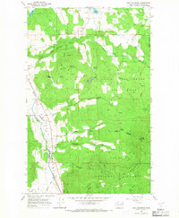
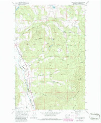
1965 Map of Addy Mountain
USGS Topo · Published 1967About this map
The Colville Valley and the northern reaches of the Iron Mountains define this mid-1960s survey of Stevens County. The landscape is a study in resource management and extraction, dominated by the sprawling Little Pend Oreille Game Range and the Colville National Forest. The Great Northern railroad follows the course of the Colville River in the west, while an Old Railroad Grade to the east suggests earlier timber or mining routes through the foothills. Local history is anchored by the community of Arden and the rural Twelvemile Sch, with numerous small-scale mining efforts indicated by scattered Prospect and Well labels near Castle Rock and The Butte. These features show a rugged Stevens County economy transitioning from early 20th-century pioneers toward modern forestry and wildlife conservation.
Find a feature on this map
34 named features on this map. Tap any name to fly to it.
Don’t see what you’re looking for? This feature index may not catch every label — zoom into the map to look around manually.
Map Details
Editions of this 1965 Addy Mountain Map
5 editions found
Other maps of this area

1927 · Chewelah
USGS Topo · 1:125,000

1929 · Colville
USGS Topo · 1:125,000

1930 · Chewelah
USGS Topo · 1:125,000

1933 · Colville
USGS Topo · 1:125,000

1952 · White Mud Lake
USGS Topo · 1:24,000

1952 · Colville
USGS Topo · 1:24,000

1958 · Sandpoint
USGS Topo · 1:250,000

1963 · Sandpoint
USGS Topo · 1:250,000

1964 · Chewelah
USGS Topo · 1:24,000

1964 · Cliff Ridge
USGS Topo · 1:24,000