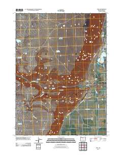
2011 Map of Adel
USGS Topo · Published 2011About this map
Adel serves as the focal point of this high-desert ranching landscape in Lake County, situated where Deep Creek flows toward the extensive wetlands of the Warner Valley. The map documents a geography defined by its water sources and family legacies, featuring numerous livestock-supporting landmarks such as Wakefield Waterhole and Bug Waterhole. The concentration of established operations like Rogers Ranch, Crump Ranch, and the M C Ranch illustrates the enduring importance of large-scale cattle ranching in this corner of Oregon. Geologic interest is found along the eastern edge, where Crump Geyser and Pelican Lake mark the transition into the valley floor. To the north and west, the terrain rises sharply toward Lynchs Rim and the Bitter Brush Basin, while Deep Creek Falls provides a rare navigational point along the canyon’s path toward the Adel Post Office.
Find a feature on this map
31 named features on this map. Tap any name to fly to it.
Don’t see what you’re looking for? This feature index may not catch every label — zoom into the map to look around manually.
Map Details
Editions of this 2011 Adel Map
This is the sole edition of this map. No revisions or reprints were ever made.
Other maps of this area

1955 · Klamath Falls
USGS Topo · 1:250,000

1955 · Adel
USGS Topo · 1:250,000

1957 · Adel
USGS Topo · 1:250,000

1958 · Klamath Falls
USGS Topo · 1:250,000

1958 · Adel
USGS Topo · 1:250,000

1962 · Adel
USGS Topo · 1:250,000

1967 · Priday Reservoir
USGS Topo · 1:24,000

1967 · Crump Lake
USGS Topo · 1:24,000
1968 · Sage Hen Butte
USGS Topo · 1:24,000
1968 · May Lake
USGS Topo · 1:24,000