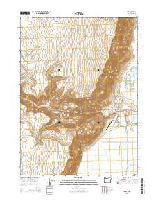
2014 Map of Adel
USGS Topo · Published 2014About this map
Adel sits at the intersection of Or-140 and Plush-Adel Rd in this high-desert landscape, where the basin floor meets the towering escarpments of Warner Rim and S Warner Rim. The geography is defined by the stark verticality of Lynchs Rim and the sprawling Warner Valley, a region where water management is central to the local economy. Evidence of irrigation and water control is visible through features like Crump Ditch and the Rodgers Reservoir, alongside natural hydrology such as Deep Creek Falls and the thermal activity at Crump Geyser. The map illustrates a rural ranching environment where life revolves around the valley floor's resources, from the Mc Ranch Airport providing aerial access to the rugged cattle country of Squaw Flat and Bitter Brush Basin.
Find a feature on this map
38 named features on this map. Tap any name to fly to it.
Don’t see what you’re looking for? This feature index may not catch every label — zoom into the map to look around manually.
Map Details
Editions of this 2014 Adel Map
This is the sole edition of this map. No revisions or reprints were ever made.
Other maps of this area

1955 · Klamath Falls
USGS Topo · 1:250,000

1955 · Adel
USGS Topo · 1:250,000

1957 · Adel
USGS Topo · 1:250,000

1958 · Klamath Falls
USGS Topo · 1:250,000

1958 · Adel
USGS Topo · 1:250,000

1962 · Adel
USGS Topo · 1:250,000

1967 · Priday Reservoir
USGS Topo · 1:24,000

1967 · Crump Lake
USGS Topo · 1:24,000
1968 · Sage Hen Butte
USGS Topo · 1:24,000
1968 · May Lake
USGS Topo · 1:24,000