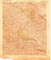
1919 Map of Adelaida
USGS Topo · Published 1919About this map
Adelaida serves as the central hub of this 1918 survey, which documents the interior highlands of the Santa Lucia Range just before the modern development of coastal California. The landscape is defined by a network of rural schoolhouses and small settlements connected by winding mountain roads like the Templeton Road. Educational landmarks including Lincoln School, Summit School, and Josephine School indicate a dispersed but established agricultural community. In the southern reaches, the Black Mine sits near the headwaters of Black Mountain (noted by label), while the German Church stands as a cultural marker in the eastern canyon country. The intricate drainage patterns of the Nacimiento River and Jack Creek illustrate a topography where narrow valleys and steep ridges dictated the placement of family holdings like Williams Ranch. This document, produced through a cooperation between the War Department and the state, provides a detailed inventory of San Luis Obispo County's rural infrastructure at the end of the First World War.
Find a feature on this map
35 named features on this map. Tap any name to fly to it.
Don’t see what you’re looking for? This feature index may not catch every label — zoom into the map to look around manually.
Map Details
Editions of this 1919 Adelaida Map
2 editions found
Other maps of this area

1897 · San Luis Obispo
USGS Topo · 1:62,500

1897 · Cayucos
USGS Topo · 1:62,500

1900 · San Luis
USGS Topo · 1:125,000

1919 · San Miguel
USGS Topo · 1:62,500

1919 · Bryson
USGS Topo · 1:62,500

1919 · Paso Robles
USGS Topo · 1:62,500

1919 · Bradley
USGS Topo · 1:62,500

1919 · Adelaida
USGS Topo · 1:62,500

1919 · San Simeon
USGS Topo · 1:62,500

1932 · Adelaida
USGS Topo · 1:62,500