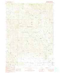
1990 Map of Adin Pass
USGS Topo · Published 1990About this map
The rugged divide between Round Valley and the northern plateau is defined by the steep slopes of Schaffer Mountain and Ryan Ridge. This 1990 survey of the Modoc National Forest territory shows a landscape transitioning from historical resource extraction to recreational use. Industrial markers like the Conklin Sawmill (Site), the Lost Cabin Mine, and multiple borrow pits suggest the area’s logging and mining legacy, while the Lower Rush Creek Cpgrd points toward modern forest management. Natural water sources are vital here, with dozens of named springs such as Hoskins Spring and Schaffer Spring feeding canyons like Higgins Canyon. The geography is anchored by the crossing at Adin Pass, where unimproved and 4WD roads traverse the timbered terrain near the Modoc County line.
Find a feature on this map
60 named features on this map. Tap any name to fly to it.
Don’t see what you’re looking for? This feature index may not catch every label — zoom into the map to look around manually.
Map Details
Editions of this 1990 Adin Pass Map
This is the sole edition of this map. No revisions or reprints were ever made.
Other maps of this area

1886 · Alturas
USGS Topo · 1:250,000

1886 · Modoc Lava Bed
USGS Topo · 1:250,000

1892 · Modoc Lava-Bed
USGS Topo · 1:250,000

1892 · Alturas
USGS Topo · 1:250,000

1954 · Alturas
USGS Topo · 1:250,000

1958 · Alturas
USGS Topo · 1:250,000

1961 · Canby
USGS Topo · 1:62,500

1961 · Bieber
USGS Topo · 1:62,500

1962 · Alturas
USGS Topo · 1:250,000

1962 · Crank Mountain
USGS Topo · 1:62,500