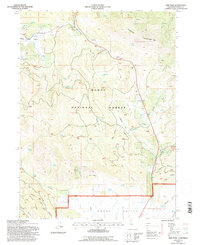
1993 Map of Adin Pass
USGS Topo · Published 1996About this map
Schaffer Mountain dominates this northern section of the Modoc National Forest, where the high-altitude terrain transitions into the broad expanse of Round Valley. This 1993 revision, based on surveys dating back to 1958, provides a clear view of the industrial and settlement history of this part of Modoc County. The presence of the Conklin Sawmill (Site) near Harris Spring and the Lost Cabin Mine tucked into the slopes of Shake Canyon point to the region's historical reliance on timber and mineral extraction.
Find a feature on this map
43 named features on this map. Tap any name to fly to it.
Don’t see what you’re looking for? This feature index may not catch every label — zoom into the map to look around manually.
Map Details
Editions of this 1993 Adin Pass Map
This is the sole edition of this map. No revisions or reprints were ever made.
Other maps of this area

1886 · Alturas
USGS Topo · 1:250,000

1886 · Modoc Lava Bed
USGS Topo · 1:250,000

1892 · Modoc Lava-Bed
USGS Topo · 1:250,000

1892 · Alturas
USGS Topo · 1:250,000

1954 · Alturas
USGS Topo · 1:250,000

1958 · Alturas
USGS Topo · 1:250,000

1961 · Canby
USGS Topo · 1:62,500

1961 · Bieber
USGS Topo · 1:62,500

1962 · Alturas
USGS Topo · 1:250,000

1962 · Crank Mountain
USGS Topo · 1:62,500