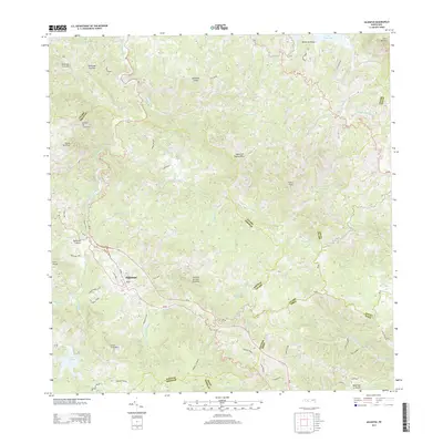
2013 Map of Adjuntas
USGS Topo · Published 2013About this map
Adjuntas sits at the heart of this central cordillera landscape, serves as a hub for the surrounding peaks and river valleys. The town is flanked by dramatic elevations such as Cerro El Gigante and Cuchilla de Juan Gonzalez, with many small quebradas and larger rivers carving through the terrain. A complex network of water resources is evident, from the Rio Grande de Arecibo to several reservoirs including Lago Adjuntas, Lago Garzas, and the southern reaches of Lago Caonillas. Transportation through this steep geography relies on routes like PR-10 and PR-123, which connect the mountain settlements to the northern and southern coasts. The map reveals a landscape dominated by its water systems and high ridges, including Monte Hormiga and Cerro Prieto, illustrating the challenging yet vital nature of this interior region of the Island of Puerto Rico.
Find a feature on this map
49 named features on this map. Tap any name to fly to it.
Don’t see what you’re looking for? This feature index may not catch every label — zoom into the map to look around manually.
Map Details
Editions of this 2013 Adjuntas Map
This is the sole edition of this map. No revisions or reprints were ever made.
Other maps of this area

1945 · Ponce
USGS Topo · 1:30,000

1946 · Utuado
USGS Topo · 1:30,000

1946 · Bayaney
USGS Topo · 1:30,000

1946 · Yauco
USGS Topo · 1:30,000

1946 · Jayuya
USGS Topo · 1:30,000

1946 · Monte Guilarte
USGS Topo · 1:30,000

1946 · Florida
USGS Topo · 1:30,000

1946 · Penuelas
USGS Topo · 1:30,000

1946 · Adjuntas
USGS Topo · 1:30,000
1947 · Yauco NE
USGS Topo · 1:10,000
Featured Places
- Adjuntas
- Sector Vickey Oquendo, Adjuntas
- Chorreras, Utuado
- Altos de Arena, Utuado
- Barriada La Olimpia, Adjuntas