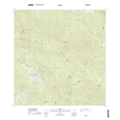
2018 Map of Adjuntas
USGS Topo · Published 2018About this map
The town of Adjuntas serves as the focal point for this survey, situated in a high-elevation landscape defined by deep river valleys and prominent peaks. The settlement is anchored by the Cementerio Municipal de Adjuntas and a network of local roads including Carr 123, which navigates the winding topography. This area is characterized by an extensive hydrological system, where the Rio Grande de Arecibo and Rio Saltillo meet a series of reservoirs like Lago Garzas and Lago Pellejas.
Find a feature on this map
75 named features on this map. Tap any name to fly to it.
Don’t see what you’re looking for? This feature index may not catch every label — zoom into the map to look around manually.
Map Details
Editions of this 2018 Adjuntas Map
This is the sole edition of this map. No revisions or reprints were ever made.
Other maps of this area

1945 · Ponce
USGS Topo · 1:30,000

1946 · Utuado
USGS Topo · 1:30,000

1946 · Bayaney
USGS Topo · 1:30,000

1946 · Yauco
USGS Topo · 1:30,000

1946 · Jayuya
USGS Topo · 1:30,000

1946 · Monte Guilarte
USGS Topo · 1:30,000

1946 · Florida
USGS Topo · 1:30,000

1946 · Penuelas
USGS Topo · 1:30,000

1946 · Adjuntas
USGS Topo · 1:30,000
1947 · Yauco NE
USGS Topo · 1:10,000
Featured Places
- Adjuntas
- Sector Vickey Oquendo, Adjuntas
- Chorreras, Utuado
- Altos de Arena, Utuado
- Barriada La Olimpia, Adjuntas