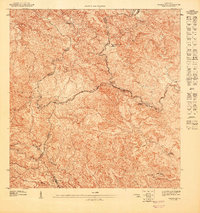
1947 Map of Adjuntas SE
USGS Topo · Published 1947About this map
Agricultural haciendas define the high-altitude landscape of the Cordillera Central on this 1947 topographic study. The terrain is divided by several municipal boundaries where Adjuntas, Jayuya, Utuado, and Ponce meet, reflecting the complex political geography of the island's interior. Scattered across these steep slopes are private agricultural estates such as Hacienda El Progreso, Hacienda Jauca, and Hacienda El Banco, which represent the coffee-producing heritage of the region.
Find a feature on this map
18 named features on this map. Tap any name to fly to it.
Don’t see what you’re looking for? This feature index may not catch every label — zoom into the map to look around manually.
Map Details
Editions of this 1947 Adjuntas SE Map
This is the sole edition of this map. No revisions or reprints were ever made.
Other maps of this area

1945 · Ponce
USGS Topo · 1:30,000

1946 · Jayuya
USGS Topo · 1:30,000

1946 · Penuelas
USGS Topo · 1:30,000

1946 · Adjuntas
USGS Topo · 1:30,000
1947 · Penuelas NE
USGS Topo · 1:10,000
1947 · Adjuntas NO
USGS Topo · 1:10,000
1947 · Adjuntas SO
USGS Topo · 1:10,000
1947 · Penuelas NO
USGS Topo · 1:10,000
1947 · Jayuya NO
USGS Topo · 1:10,000
1947 · Adjuntas NE
USGS Topo · 1:10,000