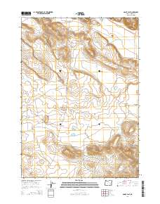
2014 Map of Adobe Flat
USGS Topo · Published 2014About this map
Anderson Valley and its high desert surroundings are defined by a complex network of seasonal water features and volcanic landforms. In this part of Harney County, life revolves around water management, evidenced by the Dracatos Reservoir and the nearby Dry Lake Reservoir. The landscape is punctuated by prominent landmarks such as Davison Butte, Kegler Butte, and the northern slopes of Little Riddle Mountain. These features, along with the Malheur Gap, create a natural corridor through which Anderson Valley Rd and Coon Town Rd pass. The map captures the remote character of the Adobe Flat area, where drainage ways like Dracatos Draw and Standcliff Cr carve through the basin, and ephemeral water bodies like Kegler Lake appear in the basin's low points.
Find a feature on this map
21 named features on this map. Tap any name to fly to it.
Don’t see what you’re looking for? This feature index may not catch every label — zoom into the map to look around manually.
Map Details
Editions of this 2014 Adobe Flat Map
This is the sole edition of this map. No revisions or reprints were ever made.
Other maps of this area

1955 · Burns
USGS Topo · 1:250,000

1958 · Burns
USGS Topo · 1:250,000

1959 · Burns
USGS Topo · 1:250,000

1960 · Crane
USGS Topo · 1:62,500

1967 · Happy Valley
USGS Topo · 1:24,000

1967 · Barton Lake
USGS Topo · 1:24,000

1967 · Diamond
USGS Topo · 1:24,000

1967 · Adobe Flat
USGS Topo · 1:24,000

1968 · Venator
USGS Topo · 1:62,500

1972 · Circle Bar
USGS Topo · 1:24,000