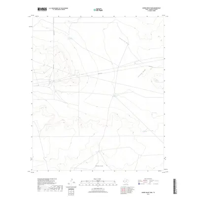
2019 Map of Adobe House Tank
USGS Topo · Published 2019About this map
Adobe House Tank sits at the heart of this arid Hudspeth County landscape, illustrating the critical role of water management in the high Chihuahuan Desert. The map captures a topography defined by significant drainage systems, where University Draw and Antelope Draw cut through the terrain toward the basin floors. Human presence in this environment is largely defined by the extensive network of cattle tanks and remote ranching infrastructure. These isolated water sources, including Cinco De Mayo Tank, Roan Tank, and Palma Tank, are the primary landmarks across the desert flats. Navigation through this territory relies on the solitary path of Ranch Rd 2317, which provides the only major vehicle access through the shifting elevations and dry creek beds like Mohawk Draw.
Find a feature on this map
10 named features on this map. Tap any name to fly to it.
Don’t see what you’re looking for? This feature index may not catch every label — zoom into the map to look around manually.
Map Details
Editions of this 2019 Adobe House Tank Map
This is the sole edition of this map. No revisions or reprints were ever made.
Other maps of this area

1903 · Cerro Alto
USGS Topo · 1:125,000

1943 · Tepee Butte
USGS Topo · 1:62,500

1943 · San Antonio Mtn
USGS Topo · 1:62,500

1951 · Red Hills
USGS Topo · 1:62,500

1954 · Van Horn
USGS Topo · 1:250,000

1955 · Cerro Diablo
USGS Topo · 1:62,500

1958 · Van Horn
USGS Topo · 1:250,000
1978 · Granite Mountain
USGS Topo · 1:24,000
1978 · Molesworth Mesa South
USGS Topo · 1:24,000
1979 · Molesworth Mesa North
USGS Topo · 1:24,000