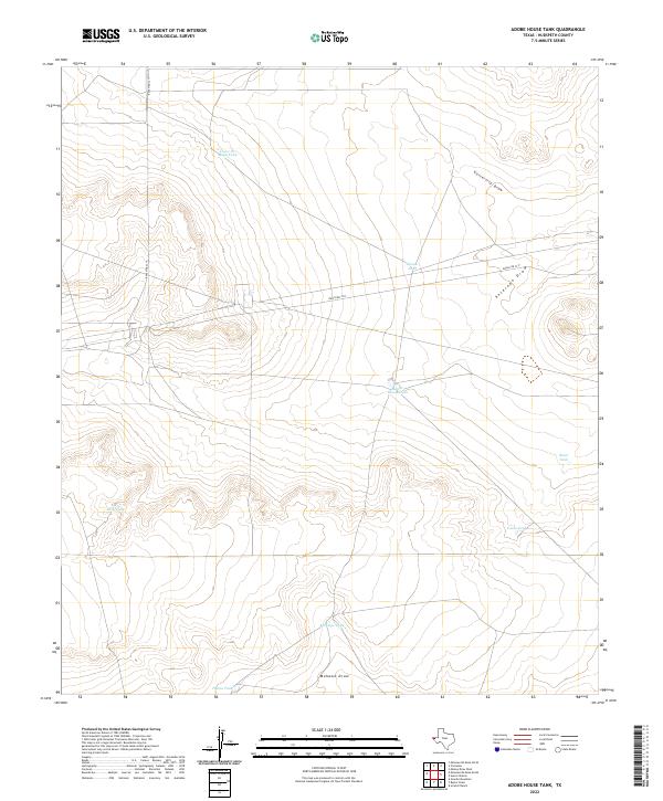
2022 Map of Adobe House Tank
USGS Topo · Published 2022About this map
Adobe House Tank sits at the center of this Hudspeth County landscape, characterized by the essential water management systems required for ranching in the high desert. The map illustrates a network of scattered water catchments, including Cinco De Mayo Tank, Llano Tank, and Deep Tank, which serve as vital landmarks across the arid terrain. These features, along with names like Tonto Tank and Roan Tank, highlight the local history of land use and the persistent search for reliable water sources in this region of Far West Texas. The drainage patterns of the area are defined by several prominent ephemeral waterways, most notably University Draw, Antelope Draw, and Mohawk Draw. These channels cut through the topography, reflecting the natural flow of seasonal runoff toward the south and east. Ranch Rd 2317 provides the primary infrastructure through the quadrangle, connecting these disparate water points and providing access to the remote ranchlands.
Find a feature on this map
12 named features on this map. Tap any name to fly to it.
Don’t see what you’re looking for? This feature index may not catch every label — zoom into the map to look around manually.
Map Details
Editions of this 2022 Adobe House Tank Map
This is the sole edition of this map. No revisions or reprints were ever made.
Other maps of this area

1903 · Cerro Alto
USGS Topo · 1:125,000

1943 · Tepee Butte
USGS Topo · 1:62,500

1943 · San Antonio Mtn
USGS Topo · 1:62,500

1951 · Red Hills
USGS Topo · 1:62,500

1954 · Van Horn
USGS Topo · 1:250,000

1955 · Cerro Diablo
USGS Topo · 1:62,500

1958 · Van Horn
USGS Topo · 1:250,000
1978 · Granite Mountain
USGS Topo · 1:24,000
1978 · Molesworth Mesa South
USGS Topo · 1:24,000
1979 · Molesworth Mesa North
USGS Topo · 1:24,000