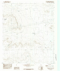
1984 Map of Adobe House Tank
USGS Topo · Published 1985About this map
Molesworth Mesa dominates the western topography of this Hudspeth County landscape, its steep escarpments overlooking a network of seasonal water drainage systems. This mid-1980s provisional survey illustrates a remote ranching environment where life and movement are dictated by the intermittent flows of University Draw and Antelope Draw. The scarcity of permanent surface water is evidenced by the strategic placement of stock tanks throughout the region, including the namesake Adobe House Tank and Cinco De Mayo Tank. These features, along with Palma Tank and Roan Tank, represent the vital infrastructure of West Texas high-desert land management. The map details a landscape of pipelines and corrals, showing how the terrain was adapted for livestock and resource management in an era before significant modern development altered these remote stretches.
Find a feature on this map
10 named features on this map. Tap any name to fly to it.
Don’t see what you’re looking for? This feature index may not catch every label — zoom into the map to look around manually.
Map Details
Editions of this 1984 Adobe House Tank Map
This is the sole edition of this map. No revisions or reprints were ever made.
Other maps of this area

1903 · Cerro Alto
USGS Topo · 1:125,000

1943 · Tepee Butte
USGS Topo · 1:62,500

1943 · San Antonio Mtn
USGS Topo · 1:62,500

1951 · Red Hills
USGS Topo · 1:62,500

1954 · Van Horn
USGS Topo · 1:250,000

1955 · Cerro Diablo
USGS Topo · 1:62,500

1958 · Van Horn
USGS Topo · 1:250,000
1978 · Granite Mountain
USGS Topo · 1:24,000
1978 · Molesworth Mesa South
USGS Topo · 1:24,000
1979 · Molesworth Mesa North
USGS Topo · 1:24,000