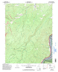
1995 Map of Adolph
USGS Topo · Published 1998About this map
Kumbrabow State Forest and the Monongahela National Forest dominate this rugged section of West Virginia, where the terrain is defined by the steep elevation of Rich Mountain and Middle Fork Ridge. The remote settlement of Adolph sits along the Middle Fk River, while the eastern edge of the map follows the winding course of the Tygart Valley River.
Find a feature on this map
67 named features on this map. Tap any name to fly to it.
Don’t see what you’re looking for? This feature index may not catch every label — zoom into the map to look around manually.
Map Details
Editions of this 1995 Adolph Map
This is the sole edition of this map. No revisions or reprints were ever made.
Other maps of this area

1889 · Beverly
USGS Topo · 1:125,000

1892 · Beverly
USGS Topo · 1:125,000

1893 · Buckhannon
USGS Topo · 1:125,000

1896 · Buckhannon
USGS Topo · 1:125,000

1897 · Buckhannon
USGS Topo · 1:125,000

1909 · Elkins
USGS Topo · 1:62,500

1912 · Sago
USGS Topo · 1:48,000

1913 · Pickens
USGS Topo · 1:48,000

1914 · Sago
USGS Topo · 1:62,500

1915 · Pickens
USGS Topo · 1:62,500