
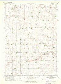
1967 Map of Adrian NE
USGS Topo · Published 1969About this map
The agricultural landscape of Nobles County is defined by the intersection of four townships: Larkin, Summit Lake, Olney, and Dewald. This 1967 survey captures a period of sophisticated prairie drainage and transport, characterized by the Judicial Ditch No 11B and County Ditch No 5 which channel water through the township lines. The region's connection to wider markets is maintained by two major rail lines, the Chicago Rock Island and Pacific in the north and the Chicago and North Western running across the southern portion. The natural drainage of Kanaranzi Creek and its East Branch Kanaranzi Creek meanders through the central fields, while Little Rock Creek flows through the southwest, illustrating the balance between natural waterways and the managed agricultural grid.
Find a feature on this map
13 named features on this map. Tap any name to fly to it.
Don’t see what you’re looking for? This feature index may not catch every label — zoom into the map to look around manually.
Map Details
Editions of this 1967 Adrian NE Map
This is the sole edition of this map. No revisions or reprints were ever made.
Other maps of this area

1954 · Fairmont
USGS Topo · 1:250,000

1958 · Fairmont
USGS Topo · 1:250,000

1960 · Reading
USGS Topo · 1:24,000

1960 · Bigelow
USGS Topo · 1:24,000

1967 · Slayton SW
USGS Topo · 1:24,000

1967 · Rushmore
USGS Topo · 1:24,000

1967 · Wilmont
USGS Topo · 1:24,000

1967 · Adrian SW
USGS Topo · 1:24,000

1967 · Adrian
USGS Topo · 1:24,000
1970 · Fulda SW
USGS Topo · 1:24,000