
1960 Map of Reading
USGS Topo · Published 1961About this map
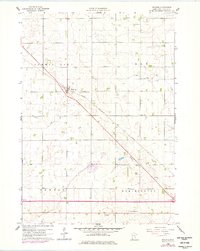
Reading serves as a central hub on this prairie landscape, positioned where the Chicago Rock Island And Pacific railroad cuts diagonally across the township lines of Summit Lake and Elk. The area is characterized by a sophisticated network of agricultural drainage, including the prominent Judicial Ditch No 8, which channels water toward Elk Creek and Okabena Creek. This 1960s-era documentation captures the region before extensive modern consolidation, preserving the location of local landmarks like the Brethren Ch and the Radio Tower (KWOA). Genealogists will find particular value in the clear demarcation of the Summit Lake Cem and the Garden of Memories, alongside rural infrastructure like the Townhall that anchored these farming communities. The map reflects a period of mid-century stability in Nobles County, showing the intersection of heavy rail transport and established township boundaries.
Find a feature on this map
18 named features on this map. Tap any name to fly to it.
Don’t see what you’re looking for? This feature index may not catch every label — zoom into the map to look around manually.
Map Details
Editions of this 1960 Reading Map
2 editions found
Other maps of this area

1954 · Fairmont
USGS Topo · 1:250,000

1958 · Fairmont
USGS Topo · 1:250,000

1960 · Bigelow
USGS Topo · 1:24,000

1960 · Worthington North
USGS Topo · 1:24,000

1960 · Worthington South
USGS Topo · 1:24,000

1967 · Rushmore
USGS Topo · 1:24,000

1967 · Wilmont
USGS Topo · 1:24,000

1967 · Adrian NE
USGS Topo · 1:24,000

1970 · Fulda
USGS Topo · 1:24,000
1970 · Fulda SW
USGS Topo · 1:24,000