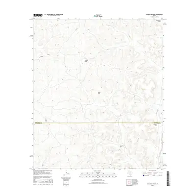
2016 Map of Aermotor Draw
USGS Topo · Published 2016About this map
Aermotor Draw and a complex network of ephemeral drainages dominate this landscape on the Edwards Plateau, where the border between Crockett and Val Verde counties cuts across the high terrain. The topography is defined by deep incisions such as Government Canyon in the northeast and Devils Draw in the southwest, reflecting the erosional patterns of this semi-arid region. These named draws, including Indian Draw and Cooper Draw, serve as the primary geographical markers in a territory largely devoid of concentrated settlements. Human presence is evidenced primarily by remote ranching infrastructure and a sparse road network. Notable routes like Ranch Rd 1973 and Juno Rd E provide access through the draws, while unpaved paths like Co Rd 402 follow the high ridges, tracing the historical movement of livestock and supplies between isolated Texas ranch lands.
Find a feature on this map
19 named features on this map. Tap any name to fly to it.
Don’t see what you’re looking for? This feature index may not catch every label — zoom into the map to look around manually.
Map Details
Editions of this 2016 Aermotor Draw Map
This is the sole edition of this map. No revisions or reprints were ever made.
Other maps of this area

1954 · Sonora
USGS Topo · 1:250,000

1958 · Sonora
USGS Topo · 1:250,000

1970 · Howards Well NE
USGS Topo · 1:24,000

1970 · Aermotor Draw
USGS Topo · 1:24,000

1970 · Steel Star Draw
USGS Topo · 1:24,000

1970 · Indian Draw
USGS Topo · 1:24,000

1970 · Bee Canyon
USGS Topo · 1:24,000

1970 · Howards Well
USGS Topo · 1:24,000

1970 · Howards Well SW
USGS Topo · 1:24,000
1970 · Harrell Canyon
USGS Topo · 1:24,000