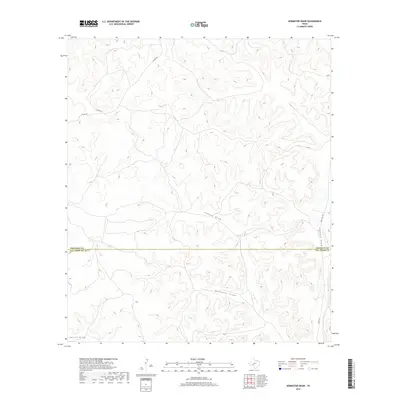
2019 Map of Aermotor Draw
USGS Topo · Published 2019About this map
Aermotor Draw cuts through the high limestone plateau of West Texas, defining a landscape shaped by intermittent drainage systems in a region where water and topography dictate human passage. This terrain marks the boundary between Crockett Co and Val Verde Co, an area defined by deep arroyos and canyons rather than established townsites. The network of seasonal watercourses, including Cooper Draw and the more significant Johnson Draw, converge as they move toward the larger Devils Draw system. Transportation in this arid environment relies on remote corridors like Ranch Rd 1973 and Juno Rd E, providing access to the vast ranching tracts that characterize this portion of the Edwards Plateau. The intricate contour lines reveal the complex erosion patterns typical of the region, where roads like Co Rd 402 follow the natural ridgelines to avoid the steep canyon floors.
Find a feature on this map
9 named features on this map. Tap any name to fly to it.
Don’t see what you’re looking for? This feature index may not catch every label — zoom into the map to look around manually.
Map Details
Editions of this 2019 Aermotor Draw Map
This is the sole edition of this map. No revisions or reprints were ever made.
Other maps of this area

1954 · Sonora
USGS Topo · 1:250,000

1958 · Sonora
USGS Topo · 1:250,000

1970 · Howards Well NE
USGS Topo · 1:24,000

1970 · Aermotor Draw
USGS Topo · 1:24,000

1970 · Steel Star Draw
USGS Topo · 1:24,000

1970 · Indian Draw
USGS Topo · 1:24,000

1970 · Bee Canyon
USGS Topo · 1:24,000

1970 · Howards Well
USGS Topo · 1:24,000

1970 · Howards Well SW
USGS Topo · 1:24,000
1970 · Harrell Canyon
USGS Topo · 1:24,000