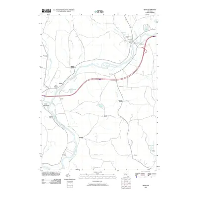
2010 Map of Afton
USGS Topo · Published 2010About this map
The Susquehanna River dictates the layout of the valley as it winds through several historic hamlets and riverfront settlements. Modern transit lines follow the ancient watercourse, passing through Afton, Nineveh, and Center Village. The rural landscape is densely dotted with genealogical points of interest, including the Baptist Cemetery, Glenwood Cemetery, and Eastside Cemetery near the northern bend of the river. To the south, family names persist in landmarks like Huggins Cemetery and the settlement of Howes. Significant upland features such as Perch Pond and Afton Lake provide a counterpoint to the river valley, while the presence of Nineveh Junction reflects the intersection of transportation corridors that have long defined this portion of Broome County. Local history is further preserved in smaller concentrations like Vallonia Springs and Doraville, which sit away from the main river corridor along the winding hill roads.
Find a feature on this map
71 named features on this map. Tap any name to fly to it.
Don’t see what you’re looking for? This feature index may not catch every label — zoom into the map to look around manually.
Map Details
Editions of this 2010 Afton Map
This is the sole edition of this map. No revisions or reprints were ever made.
Other maps of this area

1902 · Coventry
USGS Topo · 1:62,500

1904 · Oxford
USGS Topo · 1:62,500

1905 · Nineveh
USGS Topo · 1:62,500

1915 · Unadilla
USGS Topo · 1:62,500

1918 · Unadilla
USGS Topo · 1:62,500

1924 · Deposit
USGS Topo · 1:62,500

1926 · Deposit
USGS Topo · 1:62,500

1943 · Sidney
USGS Topo · 1:24,000

1944 · Deposit
USGS Topo · 1:62,500
1945 · Sidney
USGS Topo · 1:31,680