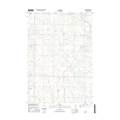
2017 Map of Afton
USGS Topo · Published 2017About this map
The unincorporated community of Afton sits at the northwest corner of this Cheboygan County terrain, where the Pigeon River and several of its tributaries, including McIntosh Cr and Kimberly Cr, carve a complex network of waterways through the landscape. The geography is defined by a series of kettle lakes and wetlands, most notably Dog Lake and Osmun Lake. This area serves as a significant recreational crossroads, featuring the intersection of major regional routes like the Shore to Shore Trail and the High Country Pathway. Local history and genealogy are centered around the Walker Township Cem located along Walker Rd. The map also details numerous family-named roads such as Brasseur Rd, Dubois Ave, and Montgomery Rd, reflecting the long-standing land ownership patterns of the township.
Find a feature on this map
51 named features on this map. Tap any name to fly to it.
Don’t see what you’re looking for? This feature index may not catch every label — zoom into the map to look around manually.
Map Details
Editions of this 2017 Afton Map
This is the sole edition of this map. No revisions or reprints were ever made.
Other maps of this area

1954 · Gaylord
USGS Topo · 1:62,500

1954 · Hetherton
USGS Topo · 1:62,500

1955 · Cheboygan
USGS Topo · 1:250,000

1957 · Tower
USGS Topo · 1:62,500

1957 · Wolverine
USGS Topo · 1:62,500

1958 · Cheboygan
USGS Topo · 1:250,000

1982 · Petoskey
USGS Topo · 1:100,000

1986 · Silver Lake
USGS Topo · 1:24,000
1986 · Legrand
USGS Topo · 1:24,000
1986 · Tower
USGS Topo · 1:24,000