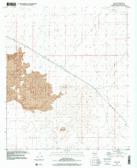
1996 Map of Afton
USGS Topo · Published 2001About this map
The Malpais dominates the western landscape of this Chihuahuan Desert region, where volcanic basalt flows meet the arid plains of southern New Mexico. The small settlement of Afton serves as a waypoint along the Southern Pacific railroad, which cuts a sharp diagonal line across the terrain. This desert corridor is defined by its water-scarce infrastructure, evidenced by scattered outposts like Norwood Well, Well, and Tank that supported the cattle and rail operations of the era. To the east, the New Mexico Principal Meridian serves as a critical surveying baseline, while the prominent volcanic cinder cone of Little Black Mountain rises from the basin floor. The map also captures the industrial footprint of the late twentieth century with the inclusion of major Pipelines traversing the northern and southern sectors, connecting the energy resources of the greater Southwest.
Find a feature on this map
10 named features on this map. Tap any name to fly to it.
Don’t see what you’re looking for? This feature index may not catch every label — zoom into the map to look around manually.
Map Details
Editions of this 1996 Afton Map
This is the sole edition of this map. No revisions or reprints were ever made.
Other maps of this area

1891 · Las Cruces
USGS Topo · 1:125,000

1893 · Las Cruces
USGS Topo · 1:125,000

1917 · Noria
USGS Topo · 1:62,500

1917 · Mt. Riley
USGS Topo · 1:62,500

1918 · Mt. Riley
USGS Topo · 1:62,500

1918 · Noria
USGS Topo · 1:62,500

1929 · Mt. Riley
USGS Topo · 1:62,500

1941 · Aden
USGS Topo · 1:62,500

1943 · Aden
USGS Topo · 1:62,500

1943 · Afton
USGS Topo · 1:62,500