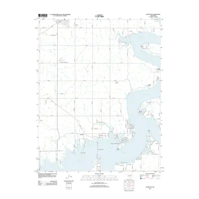
2012 Map of Afton NE
USGS Topo · Published 2012About this map
Grand Lake O' the Cherokees dominates this landscape, its winding shoreline creating a complex series of peninsulas and inlets like Sulphur Bend and Osage Hollow. The intricate waterway is punctuated by named landmarks such as Wilson Point, Hickory Point, and Catfish Point, reflecting a landscape deeply tied to the reservoir. Inland, the settlement of Copeland sits near the banks of Hickory Cr, while the northern reaches show the influence of earlier transit and community markers like the Slsf Rr corridor and Fairland Cem.
Find a feature on this map
110 named features on this map. Tap any name to fly to it.
Don’t see what you’re looking for? This feature index may not catch every label — zoom into the map to look around manually.
Map Details
Editions of this 2012 Afton NE Map
This is the sole edition of this map. No revisions or reprints were ever made.
Other maps of this area

1907 · Wyandotte
USGS Topo · 1:125,000

1909 · Wyandotte
USGS Topo · 1:125,000

1954 · Tulsa
USGS Topo · 1:250,000

1958 · Tulsa
USGS Topo · 1:250,000

1961 · Miami SE
USGS Topo · 1:24,000

1961 · Wyandotte
USGS Topo · 1:24,000

1961 · Miami SW
USGS Topo · 1:24,000

1963 · Tulsa
USGS Topo · 1:250,000
1964 · Cayuga
USGS Topo · 1:24,000

1964 · Dodge
USGS Topo · 1:24,000