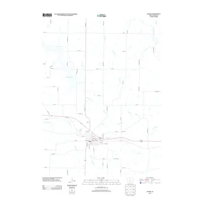
2013 Map of Afton
USGS Topo · Published 2013About this map
Afton serves as the central hub of this Iowa landscape, where the grid of town streets meets the winding paths of Threemile Cr and Twomile Cr. The local geography is defined by significant water resources, most notably the expansive Three Mile Lake to the northwest and the smaller Lake Afton situated just west of the town center. The presence of the Union County Fairgrounds near the intersection of E Filmore St and W Filmore St highlights the community's role as a regional gathering place. Transportation corridors including Old Hwy 34 and a network of gravel roads like Creamery RD and Nighthawk Ave connect the outlying farmsteads. To the east, the terrain is drained by the Thompson River and Star Br, illustrating the transition from managed lakeside recreation to the natural river valleys of Union County.
Find a feature on this map
54 named features on this map. Tap any name to fly to it.
Don’t see what you’re looking for? This feature index may not catch every label — zoom into the map to look around manually.
Map Details
Editions of this 2013 Afton Map
This is the sole edition of this map. No revisions or reprints were ever made.
Other maps of this area

1951 · Afton
USGS Topo · 1:62,500

1954 · Omaha
USGS Topo · 1:250,000

1955 · Nebraska City
USGS Topo · 1:250,000

1957 · Nebraska City
USGS Topo · 1:250,000

1957 · Omaha
USGS Topo · 1:250,000

1958 · Omaha
USGS Topo · 1:250,000

1958 · Nebraska City
USGS Topo · 1:250,000

1980 · Creston East
USGS Topo · 1:24,000

1981 · Zion
USGS Topo · 1:24,000
1981 · Arispe
USGS Topo · 1:24,000