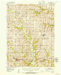
1951 Map of Afton
USGS Topo · Published 1953About this map
Afton and the surrounding townships of Union and Dodge appear as a landscape defined by small-town hubs and an extensive network of country schools and churches. The mid-century agricultural character of south-central Iowa is evident in the dense distribution of family-named burial grounds like Kivett Cem and Hamblin Cem, alongside dozens of numbered rural schoolhouses such as School No 5 and School No 7. The intersection of the Chicago Burlington and Quincy and the Chicago Great Western railroads at Talmage highlights the area's historical reliance on rail for commerce and travel. Waterways like the Thompson River and Threemile Creek wind through the terrain, with Lake Afton serving as a significant local landmark. Smaller settlements like Macksburg, Lorimor, and Thayer anchor the surrounding rural sections, each maintaining its own community identity through sites like Bethel Ch and Riverdale Sch.
Find a feature on this map
68 named features on this map. Tap any name to fly to it.
Don’t see what you’re looking for? This feature index may not catch every label — zoom into the map to look around manually.
Map Details
Editions of this 1951 Afton Map
2 editions found
Other maps of this area

1951 · Osceola
USGS Topo · 1:62,500

1951 · St. Charles
USGS Topo · 1:62,500

1951 · Afton
USGS Topo · 1:62,500

1952 · Winterset
USGS Topo · 1:62,500

1954 · Greenfield
USGS Topo · 1:62,500

1954 · Centerville
USGS Topo · 1:250,000

1954 · Omaha
USGS Topo · 1:250,000

1954 · Des Moines
USGS Topo · 1:250,000

1955 · Nebraska City
USGS Topo · 1:250,000

1956 · Des Moines
USGS Topo · 1:250,000