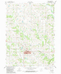
1983 Map of Afton
USGS Topo · Published 1984About this map
Afton serves as the focal point of this Union County survey, situated at the junction of the Burlington Northern and Chicago and North Western railroads. The town's civic layout is well-defined, featuring the East Union High School, Garfield Park, and a local Golf Course near Lake Afton. Beyond the town limits, the landscape is segmented into townships including Union, Dodge, and Lincoln, characterized by the drainage networks of Twelvemile Creek, Threemile Creek, and Twomile Creek.
Find a feature on this map
29 named features on this map. Tap any name to fly to it.
Don’t see what you’re looking for? This feature index may not catch every label — zoom into the map to look around manually.
Map Details
Editions of this 1983 Afton Map
This is the sole edition of this map. No revisions or reprints were ever made.
Other maps of this area

1951 · Afton
USGS Topo · 1:62,500

1954 · Omaha
USGS Topo · 1:250,000

1955 · Nebraska City
USGS Topo · 1:250,000

1957 · Nebraska City
USGS Topo · 1:250,000

1957 · Omaha
USGS Topo · 1:250,000

1958 · Omaha
USGS Topo · 1:250,000

1958 · Nebraska City
USGS Topo · 1:250,000

1980 · Creston East
USGS Topo · 1:24,000

1981 · Zion
USGS Topo · 1:24,000
1981 · Arispe
USGS Topo · 1:24,000