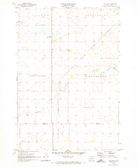
1970 Map of Agar NE
USGS Topo · Published 1973About this map
Gorman sits along the Chicago and North Western rail line, serving as a primary point of settlement in this northern South Dakota landscape. The map reveals a structured rural society organized into townships like Sanner, Gettysburg, Artichoke, and Owattonna. Local education and spiritual life are anchored by the Artichoke Sch, Owattonna Sch, and the Church of Latter Day Saints.
Find a feature on this map
12 named features on this map. Tap any name to fly to it.
Don’t see what you’re looking for? This feature index may not catch every label — zoom into the map to look around manually.
Map Details
Editions of this 1970 Agar NE Map
This is the sole edition of this map. No revisions or reprints were ever made.
Other maps of this area

1953 · Huron
USGS Topo · 1:250,000

1953 · McIntosh
USGS Topo · 1:250,000

1954 · Aberdeen
USGS Topo · 1:250,000

1954 · Pierre
USGS Topo · 1:250,000

1954 · Huron
USGS Topo · 1:250,000

1956 · Aberdeen
USGS Topo · 1:250,000

1958 · Pierre
USGS Topo · 1:250,000

1958 · McIntosh
USGS Topo · 1:250,000

1965 · Agar SW
USGS Topo · 1:24,000

1965 · Agar
USGS Topo · 1:24,000