1965 Map of Agar SW
USGS Topo · Published 1966About this map
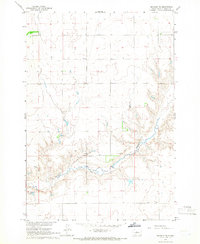
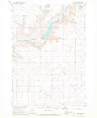
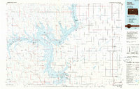
Okobojo Creek winds through the southeastern corner of this Sully County landscape, carving a distinct valley into the otherwise uniform plains of central South Dakota. The mid-1960s terrain is defined by a rigorous grid of section lines and fence lines, reflecting the organized agricultural expansion of the Missouri River Basin project era. Two rural schoolhouses, Cass Sch and Hartford Sch, serve as the primary social and community nodes for the surrounding farmsteads, which are scattered across the high ground between the drainage draws. Near the creek, several Gravel Pits indicate localized extraction of glacial deposits, providing a rare industrial footprint in a territory primarily devoted to dryland farming and cattle ranching.
Find a feature on this map
5 named features on this map. Tap any name to fly to it.
Don’t see what you’re looking for? This feature index may not catch every label — zoom into the map to look around manually.
Map Details
Editions of this 1965 Agar SW Map
This is the sole edition of this map. No revisions or reprints were ever made.
Other maps of this area

1954 · Pierre
USGS Topo · 1:250,000

1958 · Pierre
USGS Topo · 1:250,000
1965 · Artichoke Butte
USGS Topo · 1:24,000
1965 · Okobojo NE
USGS Topo · 1:24,000
1965 · Agar
USGS Topo · 1:24,000
1965 · Sully Lake
USGS Topo · 1:24,000
1970 · Agar NW
USGS Topo · 1:24,000
1970 · Agar NE
USGS Topo · 1:24,000
1970 · Artichoke Butte NE
USGS Topo · 1:24,000
1986 · Onida
USGS Topo · 1:100,000