
1970 Map of Agar NW
USGS Topo · Published 1973About this map
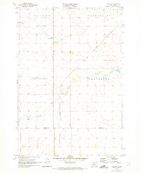
Artichoke Creek meanders through this portion of central South Dakota, serving as the primary drainage across the township boundaries of Forest City, Banner, Cattron, and Artichoke. The landscape is largely defined by the creek's valley and the infrastructure built to manage it, most notably at Gorman Dam. This topographic survey shows the rural character of the region just as photogrammetric mapping from 1969 aerial photography was being finalized for publication.
Find a feature on this map
8 named features on this map. Tap any name to fly to it.
Don’t see what you’re looking for? This feature index may not catch every label — zoom into the map to look around manually.
Map Details
Editions of this 1970 Agar NW Map
This is the sole edition of this map. No revisions or reprints were ever made.
Other maps of this area

1953 · McIntosh
USGS Topo · 1:250,000

1954 · Pierre
USGS Topo · 1:250,000

1958 · Pierre
USGS Topo · 1:250,000

1958 · McIntosh
USGS Topo · 1:250,000

1965 · Artichoke Butte
USGS Topo · 1:24,000

1965 · Agar SW
USGS Topo · 1:24,000

1965 · Agar
USGS Topo · 1:24,000

1969 · Patch Skin Buttes SE
USGS Topo · 1:24,000

1970 · Lake Hurley
USGS Topo · 1:24,000
1970 · Agar NE
USGS Topo · 1:24,000