
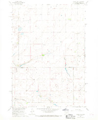
1965 Map of Sully Lake
USGS Topo · Published 1966About this map
Okobojo Creek winds through the Missouri River Basin, feeding into the prominent waters of Sully Lake in the mid-1960s. This land-use survey reveals the functional infrastructure of the era, marked by the Spillway Elevation 1739 at the lake's southern edge. The landscape is primarily defined by its drainage patterns and resource extraction, with several Gravel Pits and a smaller Gravel Pit scattered across the plains to support local road building and industry.
Find a feature on this map
8 named features on this map. Tap any name to fly to it.
Don’t see what you’re looking for? This feature index may not catch every label — zoom into the map to look around manually.
Map Details
Editions of this 1965 Sully Lake Map
This is the sole edition of this map. No revisions or reprints were ever made.
Other maps of this area

1954 · Pierre
USGS Topo · 1:250,000

1958 · Pierre
USGS Topo · 1:250,000

1965 · Artichoke Butte
USGS Topo · 1:24,000

1965 · Agar SW
USGS Topo · 1:24,000

1965 · Okobojo NE
USGS Topo · 1:24,000

1965 · Agar
USGS Topo · 1:24,000

1967 · Onida SE
USGS Topo · 1:24,000

1967 · Onida SW
USGS Topo · 1:24,000
1967 · Okobojo SE
USGS Topo · 1:24,000
1986 · Onida
USGS Topo · 1:100,000