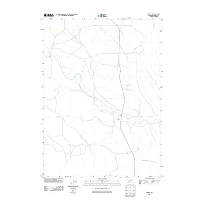
2011 Map of Agate
USGS Topo · Published 2011About this map
Agate and the surrounding High Plains terrain are defined by the meandering course of the Niobrara River, which carves a distinct valley through this corner of Sioux County. This 2011 survey documents a landscape preserved for its paleontological significance, notably within the Agate Fossil Beds Natl Monument. The mapping reveals a sparse network of ranch roads such as Nunn Rd and Panhandle Rd that traverse the uplands between water sources like Dead Mans Creek. The juxtaposition of the modern road grid against the ancient geological deposits of the Agate Fossil Beds illustrates the area's dual identity as both working ranch land and a critical site for scientific study. While the small settlement of Agate remains a central point of interest, the map primarily highlights the intersection of natural drainage patterns and the historic routes, including River Rd, that follow the valley floor.
Find a feature on this map
8 named features on this map. Tap any name to fly to it.
Don’t see what you’re looking for? This feature index may not catch every label — zoom into the map to look around manually.
Map Details
Editions of this 2011 Agate Map
This is the sole edition of this map. No revisions or reprints were ever made.
Other maps of this area

1899 · Whistle Creek
USGS Topo · 1:125,000

1955 · Alliance
USGS Topo · 1:250,000

1957 · Alliance
USGS Topo · 1:250,000

1958 · Alliance
USGS Topo · 1:250,000

1979 · Harrison SE
USGS Topo · 1:24,000

1979 · Mount Edna
USGS Topo · 1:24,000
1979 · Harrison SW
USGS Topo · 1:24,000
1979 · Agate SW
USGS Topo · 1:24,000
1979 · Agate NW
USGS Topo · 1:24,000

1979 · Agate
USGS Topo · 1:24,000