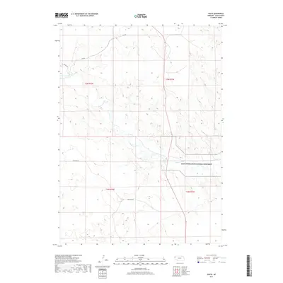
2017 Map of Agate
USGS Topo · Published 2017About this map
The Niobrara River meanders across this Sioux County landscape, cutting through the high plains of western Nebraska. Central to this map is the Agate Fossil Beds National Monument, a site renowned for its Miocene-era paleontological significance and the intersection of natural history with local ranching heritage. The terrain is defined by its drainage patterns and a sparse network of section-line roads, including Nunn Rd and Morrill Rd, which provide access to the remote townships. This survey illustrates the protected federal lands surrounding the river valley, where the preservation of prehistoric fossil beds dictates the modern land use within the Township 29 North, Range 55 West and neighboring jurisdictions. The map records the intersection of geological preservation and the traditional Nebraska range.
Find a feature on this map
9 named features on this map. Tap any name to fly to it.
Don’t see what you’re looking for? This feature index may not catch every label — zoom into the map to look around manually.
Map Details
Editions of this 2017 Agate Map
This is the sole edition of this map. No revisions or reprints were ever made.
Other maps of this area

1899 · Whistle Creek
USGS Topo · 1:125,000

1955 · Alliance
USGS Topo · 1:250,000

1957 · Alliance
USGS Topo · 1:250,000

1958 · Alliance
USGS Topo · 1:250,000

1979 · Harrison SE
USGS Topo · 1:24,000

1979 · Mount Edna
USGS Topo · 1:24,000
1979 · Harrison SW
USGS Topo · 1:24,000
1979 · Agate SW
USGS Topo · 1:24,000
1979 · Agate NW
USGS Topo · 1:24,000

1979 · Agate
USGS Topo · 1:24,000