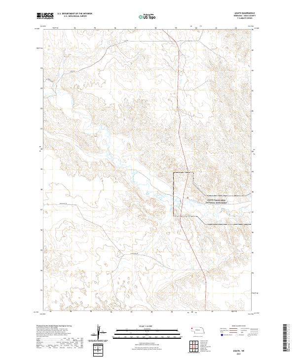
2021 Map of Agate
USGS Topo · Published 2021About this map
Agate Fossil Beds National Monument anchors this 2021 survey of the Nebraska high plains, protecting a landscape renowned for its Miocene-era paleontological sites. The Niobrara River winds through the central portion of the quadrangle, serving as the primary drainage for the surrounding draws and breaks. This is a region defined by its wide-open cattle country and section-line roads, where travel is dictated by routes like Panhandle Rd, Nunn Rd, and Morrill Rd. The map illustrates the sparsely populated character of Sioux County, showing the intersection of rural ranching life with federally protected scientific lands. Topographic detail reveals the subtle but complex drainage patterns leading toward the river valley, a terrain that has preserved ancient fossils for millions of years.
Find a feature on this map
9 named features on this map. Tap any name to fly to it.
Don’t see what you’re looking for? This feature index may not catch every label — zoom into the map to look around manually.
Map Details
Editions of this 2021 Agate Map
This is the sole edition of this map. No revisions or reprints were ever made.
Other maps of this area

1899 · Whistle Creek
USGS Topo · 1:125,000

1955 · Alliance
USGS Topo · 1:250,000

1957 · Alliance
USGS Topo · 1:250,000

1958 · Alliance
USGS Topo · 1:250,000

1979 · Harrison SE
USGS Topo · 1:24,000

1979 · Mount Edna
USGS Topo · 1:24,000
1979 · Harrison SW
USGS Topo · 1:24,000
1979 · Agate SW
USGS Topo · 1:24,000
1979 · Agate NW
USGS Topo · 1:24,000

1979 · Agate
USGS Topo · 1:24,000