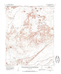
1952 Map of Agathla Peak
USGS Topo · Published 1959About this map
Monument Valley and Mystery Valley dominate this mid-century landscape within the Navajo Indian Reservation, spanning the Utah-Arizona border. The map documents a complex network of high desert landforms, including the iconic West Mitten Butte, East Mitten Butte, and Merrick Butte. Human history is recorded through various eras, from a Pueblo Site and the House of Hands (Cave) to the industrial presence of Monument No 1 Tunnel and the Monument No 1 Annex.
Find a feature on this map
59 named features on this map. Tap any name to fly to it.
Don’t see what you’re looking for? This feature index may not catch every label — zoom into the map to look around manually.
Map Details
Editions of this 1952 Agathla Peak Map
3 editions found

Other maps of this area

1883 · Marsh Pass
USGS Topo · 1:250,000

1886 · Henry Mountains
USGS Topo · 1:250,000

1886 · Abajo
USGS Topo · 1:250,000

1892 · Marsh Pass
USGS Topo · 1:250,000

1892 · Abajo
USGS Topo · 1:250,000

1892 · Henry Mountains
USGS Topo · 1:250,000

1892 · Canyon De Chelly
USGS Topo · 1:250,000

1893 · Abajo
USGS Topo · 1:250,000

1952 · Clay Hills 4 SW
USGS Topo · 1:24,000

1952 · Clay Hills 3 SE
USGS Topo · 1:24,000