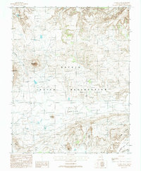
1988 Map of Agathla Peak
USGS Topo · Published 1988About this map
Agathla Peak (El Capitan) stands as the dominant volcanic landmark in this high-desert landscape within the Navajo Indian Reservation. The terrain is characterized by striking geological formations, including the prominent spires of Chaistla Butte and the dramatic uplift of Comb Ridge in the southeast. This 1988 provisional edition captures the complex drainage patterns of El Capitan Wash and Laguna Creek, along with various water management efforts such as a Check Dam near the Gray Hills. Cultural features are sparse but significant, with the Little Capitan Valley serving as a focal point for movement across the region. Notable named rock formations like Owl Rock and Lion Rock provide essential navigation points, while the intricate system of the Porras Dikes reveals the subterranean volcanic history of the Arizona desert.
Find a feature on this map
18 named features on this map. Tap any name to fly to it.
Don’t see what you’re looking for? This feature index may not catch every label — zoom into the map to look around manually.
Map Details
Editions of this 1988 Agathla Peak Map
This is the sole edition of this map. No revisions or reprints were ever made.
Other maps of this area

1883 · Marsh Pass
USGS Topo · 1:250,000

1892 · Marsh Pass
USGS Topo · 1:250,000

1952 · Agathla Peak 1 NW
USGS Topo · 1:24,000

1952 · Boot Mesa
USGS Topo · 1:62,500

1952 · Agathla Peak 1 NE
USGS Topo · 1:24,000

1952 · Agathla Peak 2 SE
USGS Topo · 1:24,000

1952 · Agathla Peak 1 SE
USGS Topo · 1:24,000

1952 · Agathla Peak 2 NE
USGS Topo · 1:24,000

1952 · Agathla Peak
USGS Topo · 1:62,500

1952 · Agathla Peak 1 SW
USGS Topo · 1:24,000