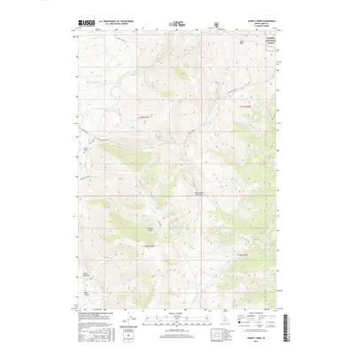
2017 Map of Agency Creek
USGS Topo · Published 2017About this map
The Beaverhead Mountains dominate this 2017 terrain, marking a dramatic landscape where water sources like Agency Creek and the Lemhi River shape the local geography. This high-altitude region within the Salmon National Forest preserves significant cultural and historical markers, most notably the Chief Tendoy Cem situated near the intersection of Chief Tendoy Rd and the Lewis and Clark Hwy. The transportation network follows the natural contours of the land, with Agency Crk Rd winding through the basin and Alkali Flat Rd cutting across the northern reaches. Numerous springs and gulches, including Eckersell Spring and Big Dry Gulch, indicate a complex hydrological system that has long influenced movement through these mountain passes. The map also identifies local landmarks such as Gould Basin and Napo Canyon, illustrating the varied topography of this Lemhi County area.
Find a feature on this map
29 named features on this map. Tap any name to fly to it.
Don’t see what you’re looking for? This feature index may not catch every label — zoom into the map to look around manually.
Map Details
Editions of this 2017 Agency Creek Map
This is the sole edition of this map. No revisions or reprints were ever made.
Other maps of this area

1955 · Dubois
USGS Topo · 1:250,000

1955 · Dillon
USGS Topo · 1:250,000

1956 · Goldstone Mtn
USGS Topo · 1:62,500

1956 · Lemhi
USGS Topo · 1:62,500

1957 · Dillon
USGS Topo · 1:250,000

1958 · Dubois
USGS Topo · 1:250,000

1958 · Dillon
USGS Topo · 1:250,000

1962 · Dillon
USGS Topo · 1:250,000

1965 · Dillon
USGS Topo · 1:250,000

1965 · Lemhi Pass
USGS Topo · 1:24,000