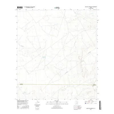
2016 Map of Agua Azul Creek East
USGS Topo · Published 2016About this map
Agua Azul Creek defines the drainage of this South Texas brushland, where the terrain transitions across the boundary of Webb and Zapata counties. The landscape is largely characterized by intermittent watercourses and ranching infrastructure, such as Vaquillas Ranch Lake Number 4 and Fred M Bruni Lake Number 1. These named water features, likely cattle tanks or reservoirs, indicate the vital role of water management in this arid environment. Transportation through the area is limited to established ranch corridors, specifically Ranch Rd 7070B and Ranch Rd 8010B, which provide access to the various grazing lands. Other local drainages like Albercas Cr, Burrocito Cr, and Chargos Cr further illustrate the seasonal hydrology of the region.
Find a feature on this map
10 named features on this map. Tap any name to fly to it.
Don’t see what you’re looking for? This feature index may not catch every label — zoom into the map to look around manually.
Map Details
Editions of this 2016 Agua Azul Creek East Map
This is the sole edition of this map. No revisions or reprints were ever made.
Other maps of this area

1939 · Bruni
USGS Topo · 1:62,500

1939 · Randado
USGS Topo · 1:62,500

1940 · Aguilares
USGS Topo · 1:62,500

1940 · Randado
USGS Topo · 1:62,500

1940 · Mogotes Hill
USGS Topo · 1:62,500

1956 · Mogotes Hill
USGS Topo · 1:62,500

1956 · Laredo
USGS Topo · 1:250,000

1972 · Albercas Ranch
USGS Topo · 1:24,000
1972 · Oilton
USGS Topo · 1:24,000
1972 · Thompsonville
USGS Topo · 1:24,000