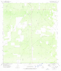
1972 Map of Thompsonville
USGS Topo · Published 1975About this map
Thompsonville sits at the heart of this South Texas landscape, marking a localized center of activity within the brush country of Jim Hogg County and Zapata County. The terrain is defined by the broad drainage of the Arroyo Grande, which cuts diagonally across the quadrangle. By the early 1970s, the region's economy was clearly driven by petroleum extraction and ranching, evidenced by a dense network of Oil Wells and numerous Drill Holes scattered across the plains.
Find a feature on this map
12 named features on this map. Tap any name to fly to it.
Don’t see what you’re looking for? This feature index may not catch every label — zoom into the map to look around manually.
Map Details
Editions of this 1972 Thompsonville Map
2 editions found
Other maps of this area

1939 · Bruni
USGS Topo · 1:62,500

1939 · Randado
USGS Topo · 1:62,500

1940 · Aguilares
USGS Topo · 1:62,500

1940 · Randado
USGS Topo · 1:62,500

1940 · Mogotes Hill
USGS Topo · 1:62,500

1956 · Mogotes Hill
USGS Topo · 1:62,500

1956 · Laredo
USGS Topo · 1:250,000

1972 · Armstrong Ranch
USGS Topo · 1:24,000
1972 · San Pablo Ranch
USGS Topo · 1:24,000

1972 · Albercas Ranch
USGS Topo · 1:24,000