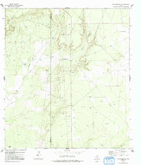
1972 Map of Thompsonville
USGS Topo · Published 1992About this map
Thompsonville serves as the focal point of this South Texas landscape, situated along the county line separating Zapata and Jim Hogg counties. This 1970s survey captures a region defined by energy infrastructure and ranching, where a network of pipelines and numerous oil wells crisscross the brushland. The terrain is deeply inscribed by the winding course of Arroyo Grande, which provides the primary geographic relief to the otherwise steady topography. Isolated landmarks such as the Vela-Peña Ranch and Peyote Tank suggest the sparse, enduring settlement patterns of the area, while a remote Landing Strip and a Pumping Sta reflect the logistical requirements of the local petroleum industry and remote ranch management during this era.
Find a feature on this map
12 named features on this map. Tap any name to fly to it.
Don’t see what you’re looking for? This feature index may not catch every label — zoom into the map to look around manually.
Map Details
Editions of this 1972 Thompsonville Map
2 editions found
Other maps of this area

1939 · Bruni
USGS Topo · 1:62,500

1939 · Randado
USGS Topo · 1:62,500

1940 · Aguilares
USGS Topo · 1:62,500

1940 · Randado
USGS Topo · 1:62,500

1940 · Mogotes Hill
USGS Topo · 1:62,500

1956 · Mogotes Hill
USGS Topo · 1:62,500

1956 · Laredo
USGS Topo · 1:250,000

1972 · Armstrong Ranch
USGS Topo · 1:24,000
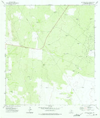
1972 · San Pablo Ranch
USGS Topo · 1:24,000

1972 · Albercas Ranch
USGS Topo · 1:24,000