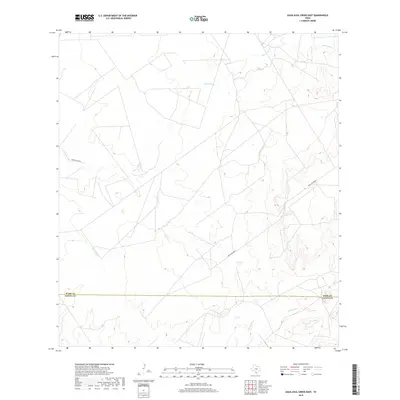
2019 Map of Agua Azul Creek East
USGS Topo · Published 2019About this map
Agua Azul Cr meanders across this South Texas landscape, defining the drainage patterns of the brush country along the border of Webb and Zapata counties. The terrain is characterized by intermittent watercourses like Albercas Cr, Chargos Cr, and Barrocito Cr, which carve subtle relief into the arid ranchland. Human presence is primarily represented by a network of private ranch roads and two secondary arteries, Ranch Rd 7070B and Ranch Rd 8010B, which facilitate movement between scattered livestock operations. This 2019 survey documents a sparsely settled area where the management of large land tracts and seasonal water flow remains the dominant feature of life and commerce.
Find a feature on this map
7 named features on this map. Tap any name to fly to it.
Don’t see what you’re looking for? This feature index may not catch every label — zoom into the map to look around manually.
Map Details
Editions of this 2019 Agua Azul Creek East Map
This is the sole edition of this map. No revisions or reprints were ever made.
Other maps of this area

1939 · Bruni
USGS Topo · 1:62,500

1939 · Randado
USGS Topo · 1:62,500

1940 · Aguilares
USGS Topo · 1:62,500

1940 · Randado
USGS Topo · 1:62,500

1940 · Mogotes Hill
USGS Topo · 1:62,500

1956 · Mogotes Hill
USGS Topo · 1:62,500

1956 · Laredo
USGS Topo · 1:250,000

1972 · Albercas Ranch
USGS Topo · 1:24,000
1972 · Oilton
USGS Topo · 1:24,000
1972 · Thompsonville
USGS Topo · 1:24,000