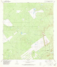
1980 Map of Agua Azul Creek East
USGS Topo · Published 1980About this map
The south Texas brush country along the Webb Co Zapata Co border is defined here by its hydraulic and industrial networks in the late 1970s. The landscape is drained by seasonal watercourses including Agua Azul Creek, Barrocito Creek, and Chargos Creek, which weave through terrain marked by intensive energy extraction. Scattered clusters of Gas Wells, Oil Wells, and numerous Drill Holes indicate the ongoing expansion of local energy fields during this era. A prominent Pipeline cuts across the southwestern quadrant, illustrating the infrastructure required to transport resources from these isolated drilling sites. The map also shows an Indefinite Boundary and the reach of Albercas Creek, providing a detailed look at the rural topography and land use patterns before further modern development in the Rio Grande Valley hinterlands.
Find a feature on this map
12 named features on this map. Tap any name to fly to it.
Don’t see what you’re looking for? This feature index may not catch every label — zoom into the map to look around manually.
Map Details
Editions of this 1980 Agua Azul Creek East Map
This is the sole edition of this map. No revisions or reprints were ever made.
Other maps of this area

1939 · Bruni
USGS Topo · 1:62,500

1939 · Randado
USGS Topo · 1:62,500

1940 · Aguilares
USGS Topo · 1:62,500

1940 · Randado
USGS Topo · 1:62,500

1940 · Mogotes Hill
USGS Topo · 1:62,500

1956 · Mogotes Hill
USGS Topo · 1:62,500

1956 · Laredo
USGS Topo · 1:250,000

1972 · Albercas Ranch
USGS Topo · 1:24,000
1972 · Oilton
USGS Topo · 1:24,000
1972 · Thompsonville
USGS Topo · 1:24,000